

Si deseas distinguir tus productos, servicios o ambos de los de otra empresa, es posible que necesites una marca o nombre comercial. Descubre qué son, en qué consiste su procedimiento de registro y qué implica.

Información sobre los plazos de presentación de solicitudes de transformación de marcas de la Unión Europea en marca nacional española. Más información


Si tienes un nuevo dispositivo, producto o procedimiento que resuelva un problema técnico o tenga una ventaja práctica, existen distintas formas de protegerlo en España y en otros países. Descubre cómo hacerlo.

¿Tu innovación reside en la estética, la ornamentación o la apariencia de tu producto? Protégela mediante un diseño industrial. Descubre qué derechos confiere el registro y cómo realizar la tramitación.

Las indicaciones geográficas protegen el nombre de un producto originario de una zona geográfica, a la cual le debe una determinada calidad, reputación u otra característica. Descubre qué son, en qué consiste su procedimiento de registro y qué beneficios conceden.

Las patentes publicadas en todo el mundo son una valiosa fuente de información científica, técnica y comercial.

Si eres emprendedor/a o una empresa y quieres potenciar y mejorar la rentabilidad de tu negocio protegiendo de forma adecuada los activos intangibles de tu organización, en este espacio encontrarás lo necesario.


 47
resultados
47
resultados
 Última actualización
30/06/2026 [07:30:00]
Última actualización
30/06/2026 [07:30:00]


Resumen de: WO2026132886A1
The invention of smart asphalt with predictive, diagnostic, and anti-icing capabilities for improving safety and reducing accidents at urban intersections and intercity roads includes a network of sensors that collect data related to environmental conditions and road surface features. This data is then processed using AI algorithms to predict and detect the formation of black ice on the asphalt surface. Upon detecting or predicting the occurrence of black ice, a heating system embedded within the asphalt layers generates appropriate heat to prevent ice formation. Depending on the type and characteristics of each data, different AI algorithms are employed, and the accuracy of prediction and detection is improved using data fusion techniques. The system generates a real-time map of the location and extent of identified and predicted ice formation, enhancing the safety and maintenance of the road network.

Resumen de: WO2026133469A1
The present invention makes it possible to improve the operation rate of a charging facility managed by a business operator operating a mobile body. This information processing device includes: a first acquisition unit that acquires travel information including position information about a mobile body on which a chargeable battery is mounted; a second acquisition unit that acquires charging facility information including position information about a charging facility used for charging the battery, the operation state of the charging facility, and manager information pertaining to a manager of the charging facility; a generation unit that generates available charging facility information, including candidates for the charging facility used for charging the battery of the mobile body, on the basis of the travel information and the charging facility information; and a notification unit that notifies the mobile body of the available charging facility information. When a charging facility managed by a first business operator operating a first mobile body is available, the notification unit notifies a second mobile body, operated by a business operator different from the first business operator, that the charging facility managed by the first business operator can be used for charging a battery of the second mobile body.
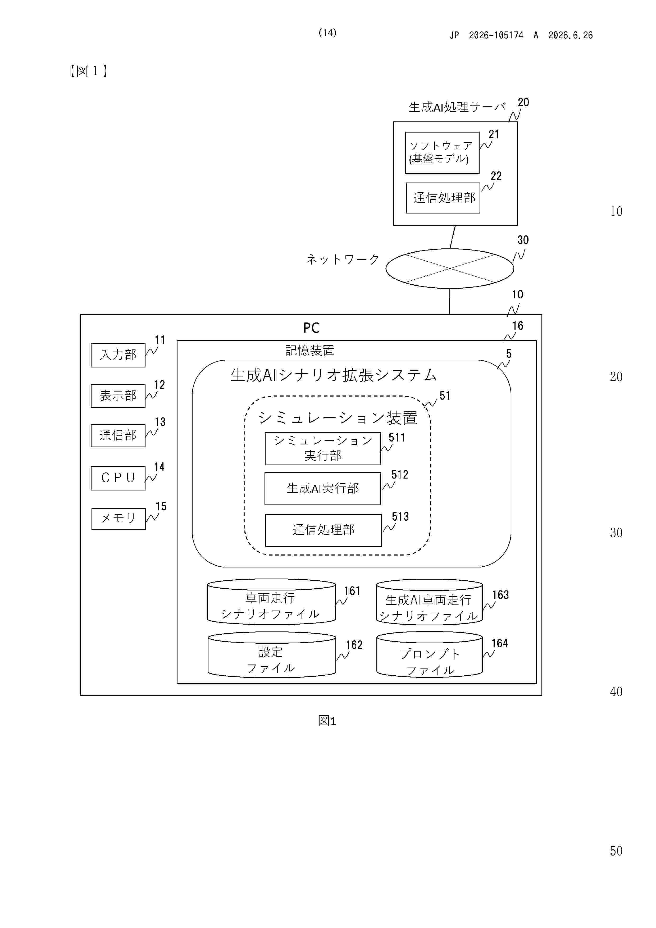
Resumen de: WO2026133596A1
The present invention makes it possible to create desired scenario data in a simulation of autonomous driving, for example, with reduced labor. This scenario data generation system includes a storage device and a processor. The storage device stores scenario data that includes information about operations of one or more objects at each sample time in a scene in which the one or more objects operate, and prompt data that instructs a generative artificial intelligence to perform a desired operation of each object. The processor starts a step-by-step simulation at each sample time based on the scenario data, causes, in each step, the generative artificial intelligence to generate a next state that is a state of the object at the next sample time due to the desired operation based on the state of the object in the scenario data, updates the state of the object at the next sample time in the scenario data to the next state, and outputs the scenario data when the simulation is completed.
Resumen de: WO2026132692A1
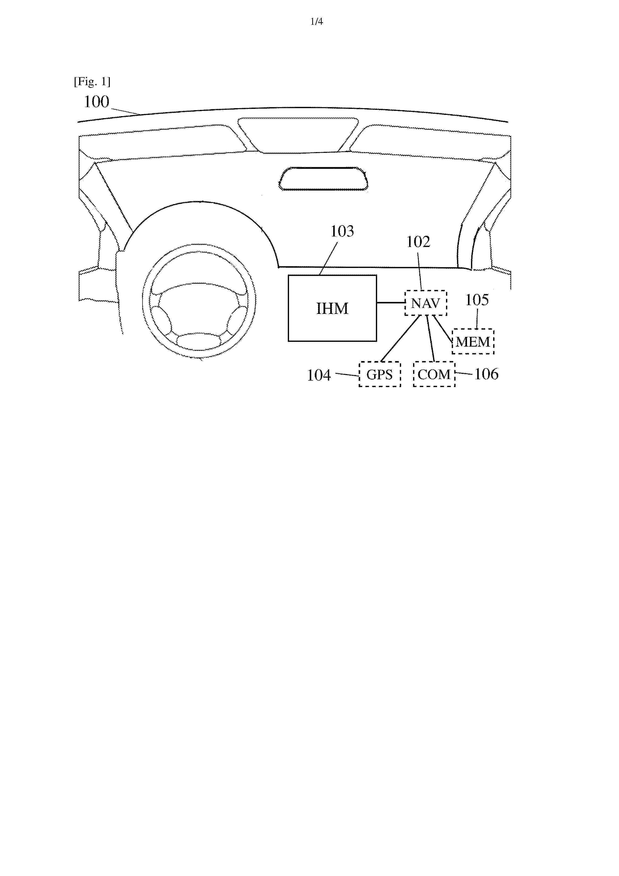
The invention relates to a method for controlling a warning function that can provide a warning when a vehicle is being guided towards a limited traffic zone. The method comprises determining (200) the coordinates of a usual address of a vehicle user. If the usual address is inside a first limited traffic zone from a set containing at least one limited traffic zone, a perimeter is defined (202) around the usual address. When the user indicates (211) a destination in a navigation function of the vehicle, the warning function is disabled (215) if the destination is inside the first limited traffic zone and the defined perimeter.
Resumen de: WO2026136277A1
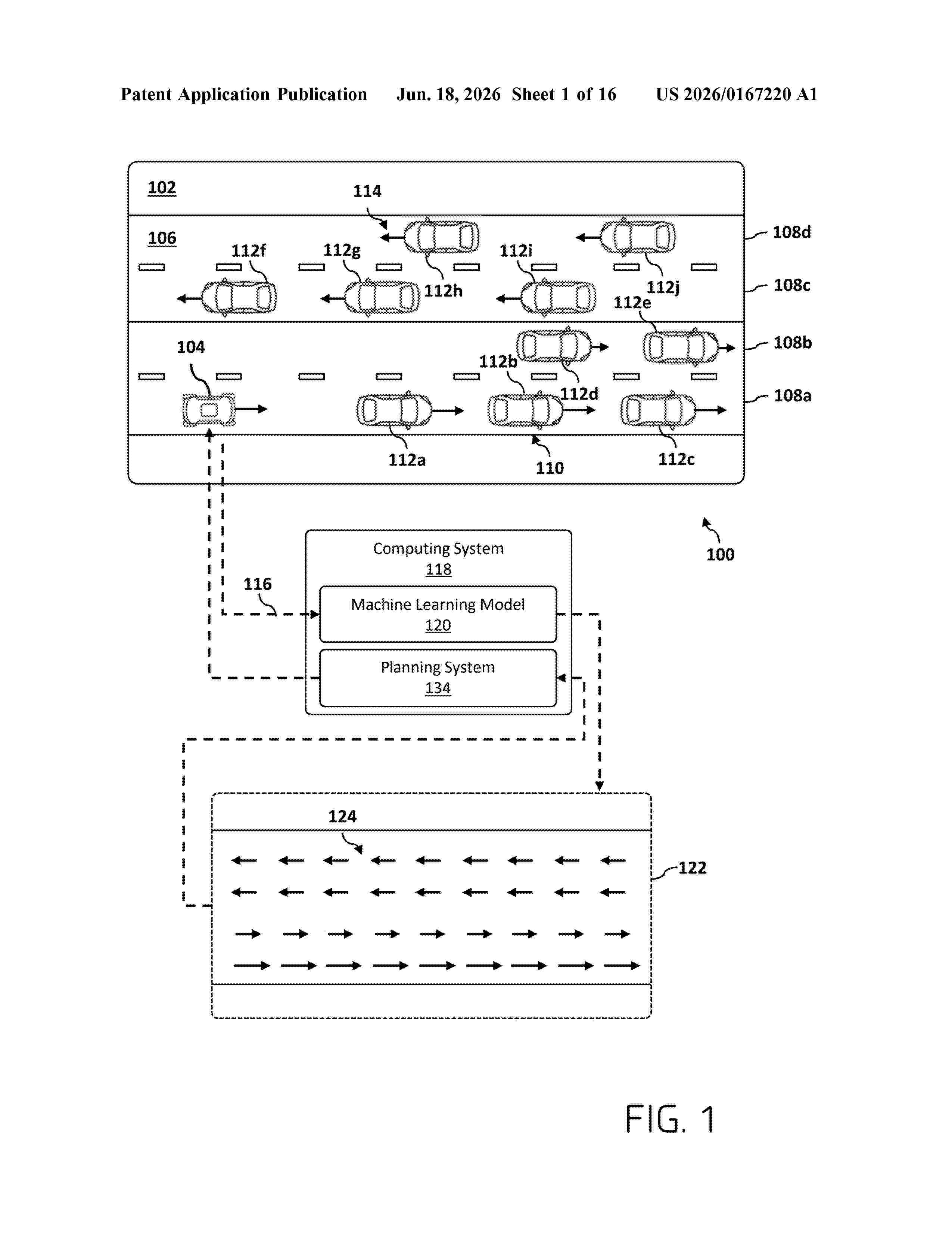
Techniques described herein involve a determination of a set of vectors associated with a vector field that is indicative of a traffic direction in the environment. Data associated with an environment in a vicinity of a vehicle is received. Based on the data, a set of vectors associated with a vector field that is indicative of a traffic direction in the environment is determined. The vectors in the set of vectors are indicative of the traffic direction at respective positions in the environment. Instructions are generated to control the vehicle based at least in part on the set of vectors.
Resumen de: WO2026133781A1
This data processing method comprises: a step in which conditions including a road section which includes a series of a plurality of intersections, and including a traveling direction of a vehicle in the road section and a time slot, and simulation results from a traffic simulator conforming to a designated signal control parameter related to the plurality of intersections are acquired; a step in which the simulation results are output; a step in which, after an adjustment of the signal control parameter, the simulation results are updated using the adjustment, and the updated simulation results are used to evaluate the adjustment for a change in situation with respect to the conditions; and a step in which data related to the results of the evaluation are output.
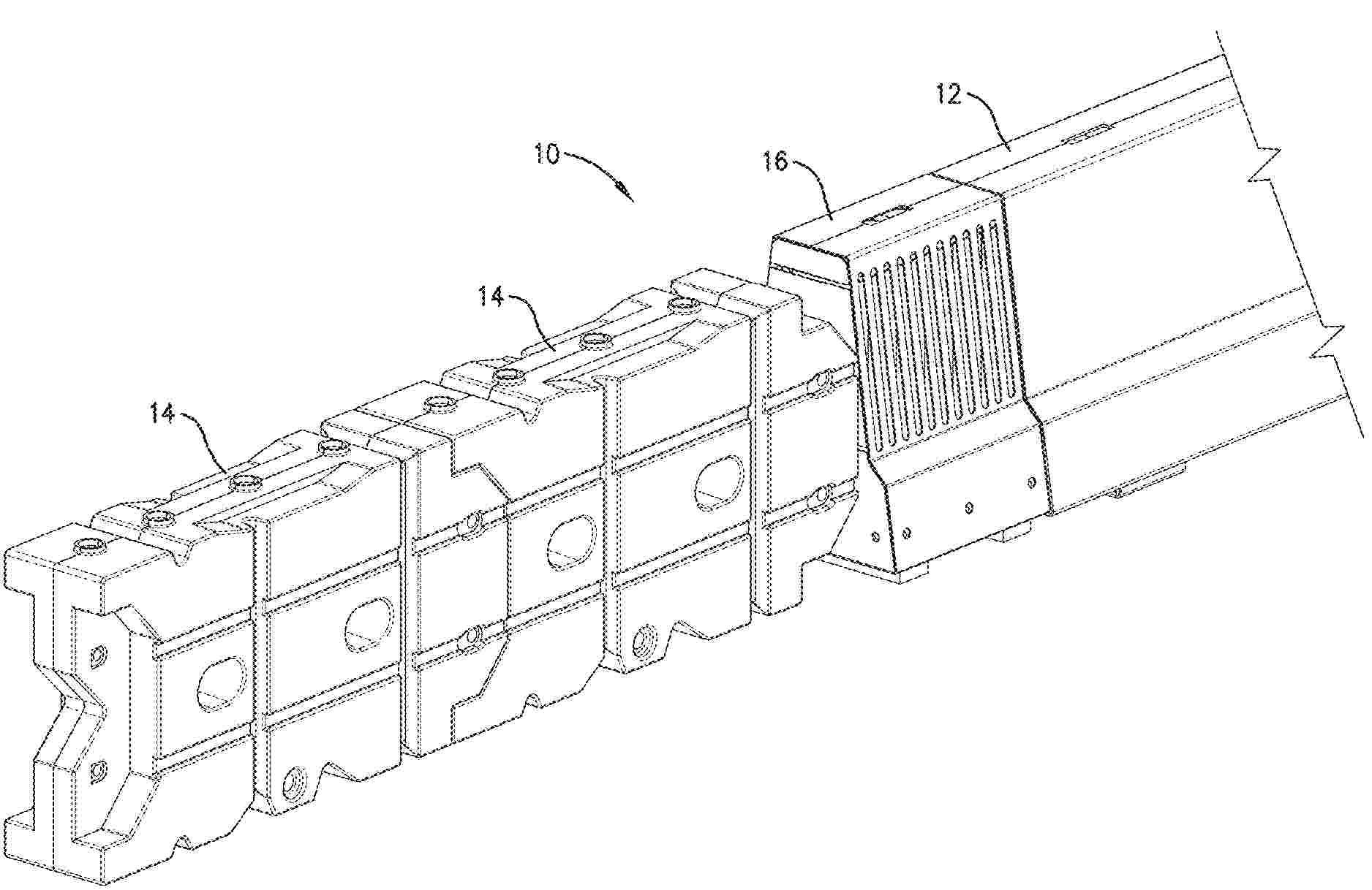
Resumen de: WO2026136457A1
Sustainable bike lane barriers are provided. The sustainable bike lane barrier system includes a plurality of sustainable bike lane barriers interconnected with each other. Each sustainable bike lane barrier of the plurality of sustainable bike lane barriers includes a protrusion and a cavity. The protrusion of a first sustainable bike lane barrier of the plurality of sustainable bike lane barriers is inserted into the cavity of a second sustainable bike lane barrier of the plurality of sustainable bike lane barriers. The sustainable bike lane barrier system also includes at least one fastener extending through the protrusion of the first sustainable bike lane barrier, the cavity of the second sustainable bike lane barrier, and into the ground to interlock the plurality of sustainable bike lane barriers and to secure the sustainable bike lane barrier system to the ground.
Resumen de: WO2025038186A1
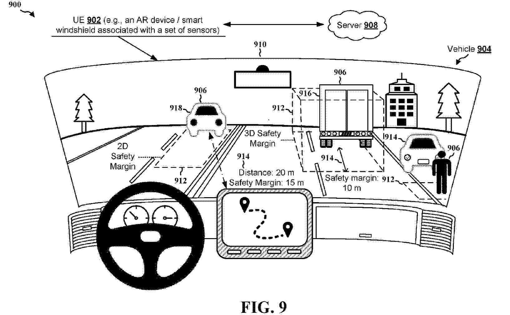
Aspects presented herein may enable a UE (e.g., a vehicle, an autonomous vehicle, an on-board unit (OBU) of a vehicle, an advanced driver assistance systems (ADAS) of a vehicle) to calculate and output safety margins for objects around the UE or a vehicle. In one aspect, a UE receives or transmits a request to provide safety margin visualization assistance. The UE obtains, in response to the request, an indication of a safety margin associated with an object based on a distance between the UE and the object and at least one of: a size of the object, a speed of the object, a location of the object, a type of the object, a direction of the object, or a movement pattern of the object. The UE outputs the safety margin associated with the object.
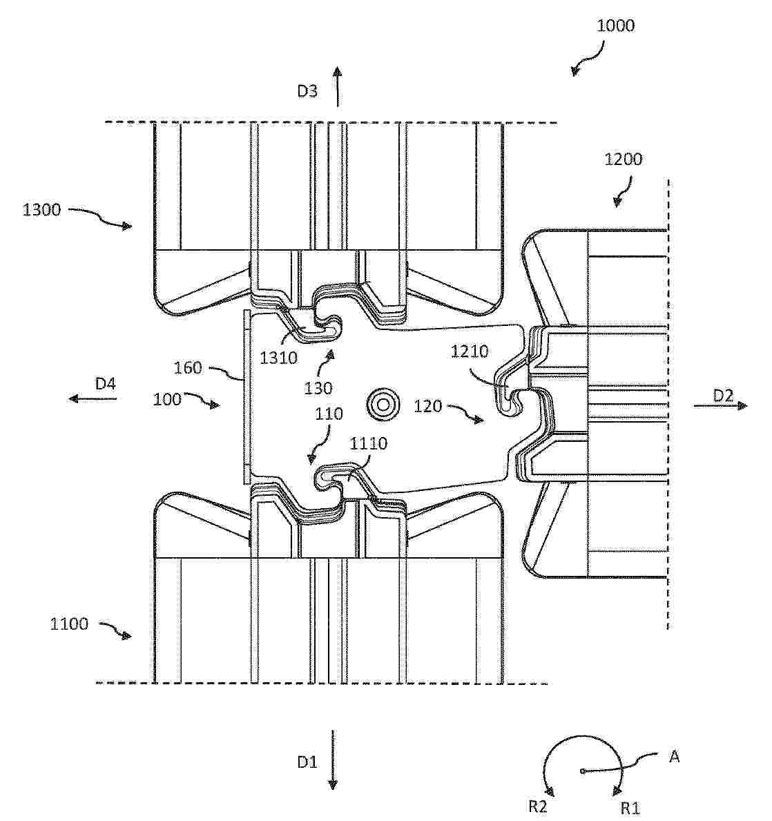
Resumen de: EP4764079A1
There is provided a connection element (100) for detachably connecting three heavy-duty barriers to each other. The connection element (100) comprising: a first coupling portion (110) detachably connectable to a corresponding coupling portion (1110) of a first heavy-duty barrier (1100); a second coupling portion (120) detachably connectable to corresponding coupling portion (1210) of a second heavy-duty barrier (1200), and a third coupling portion (130) detachably connectable to a corresponding coupling portion (1310) of a third heavy-duty barrier (1300). The connection element (100) is arranged to interlock with each of the first, second, and third heavy-duty barriers (1100, 1200, 1300).
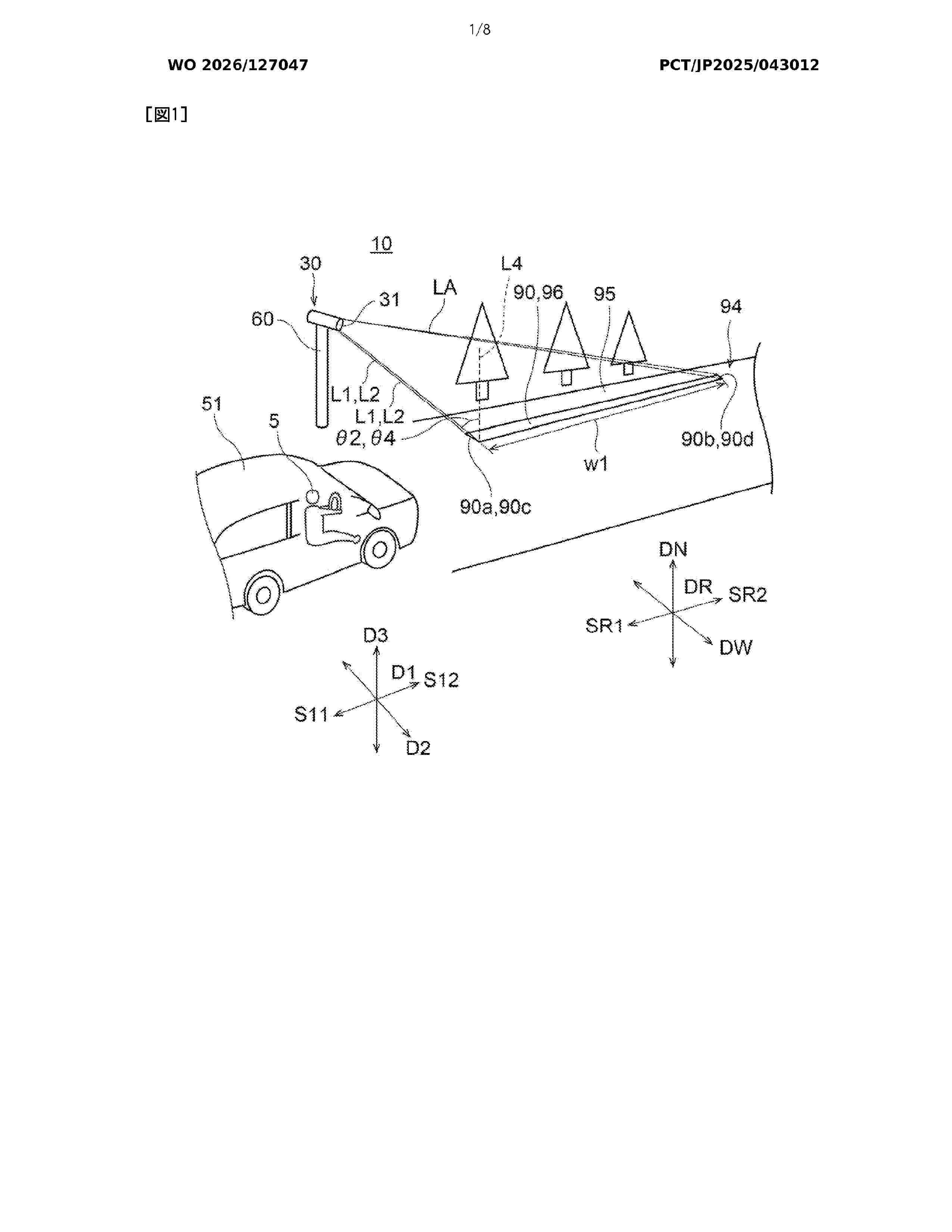
Resumen de: WO2026127047A1
A road display device 10 comprises a lighting device 30 that irradiates a road surface 95 with light so as to project a display having a width at least in a first direction. The display has a first end portion 90a located on a first side S11 in a first direction D1. In observation from a vertical direction DN, an angle Φ1 formed by a first light beam L1 and a virtual line segment L3 is smaller than 90°, the first light beam L1 being emitted from the lighting device 30 to the first end portion 90a, the virtual line segment L3 extending from the first end portion 90a to the first side S11 along the first direction D1. In observation from a second direction D2 perpendicular to the first direction D1 and perpendicular to the vertical direction DN, an angle θ1 formed by the first light beam L1 and a perpendicular line L4 to the road surface 95 is larger than 0° and is 83.15° or smaller.
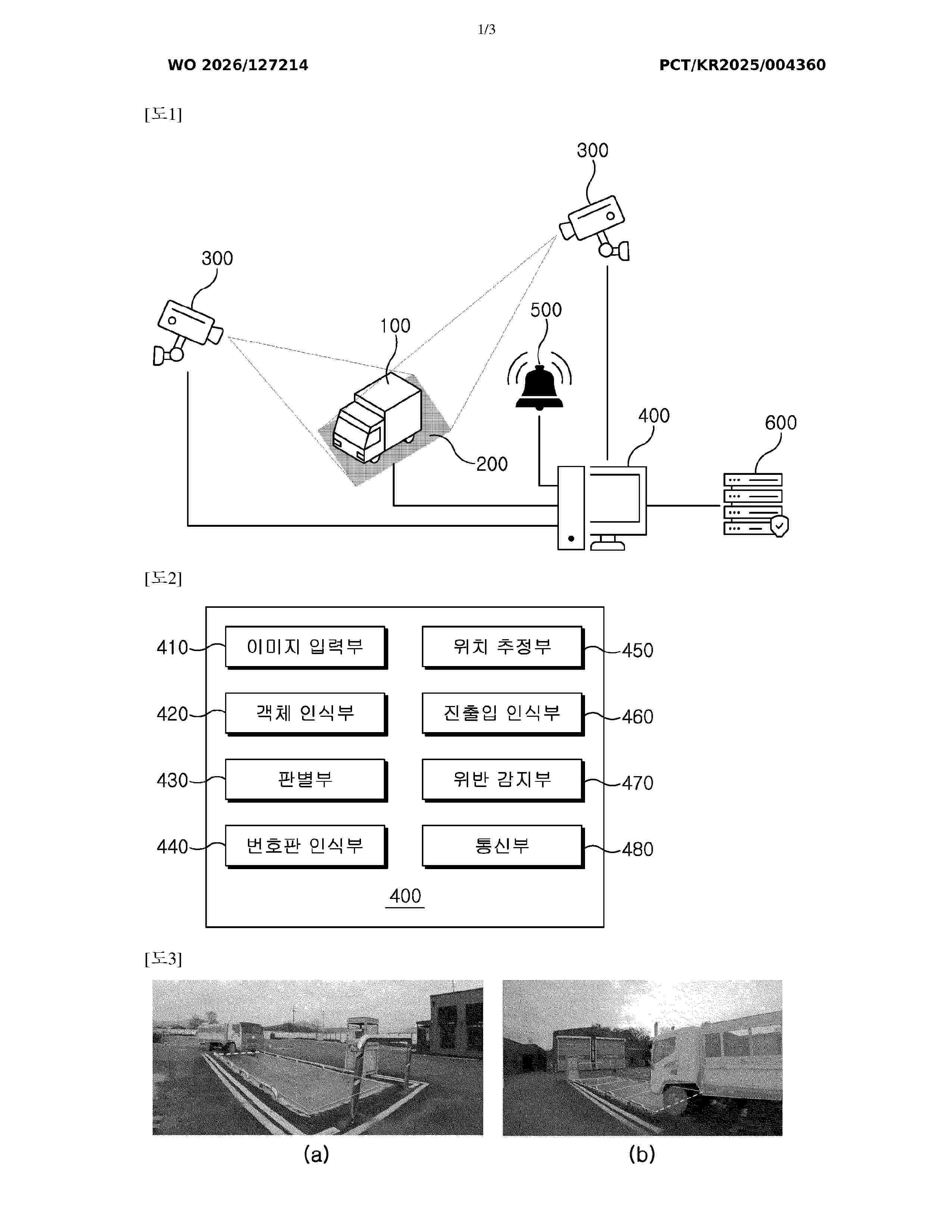
Resumen de: WO2026127214A1
The present invention relates to an apparatus for monitoring a weighing violation of a vehicle and an operating method thereof and, more specifically, the apparatus comprises: a vehicle; a weighbridge for measuring the weight of the vehicle; one or more cameras for photographing the vehicle and the weighbridge; a detection device for detecting, by using artificial intelligence, whether the weight of the vehicle is normal on the basis of an image captured by the camera; and an alarm unit for notifying a driver of the vehicle of a weighing violation, and thus, the weighing violation may be automatically detected without manpower and notified to the driver.
Resumen de: EP4761218A1
The disclosure relates to a computer system (600) for handling configurations for an at least partly autonomous vehicle (100), the computer system (600) comprising processing circuitry (602) configured to:- at vehicle startup, determine a current geographical zone in which the vehicle (100) is currently located;- compare the current geographical zone with a last known geographical zone to determine if the current geographical zone is part of the last known geographical zone or not;- obtain a new vehicle configuration for the current geographical zone when the current geographical zone is not part of the last known geographical zone; and to- determine whether or not to update the vehicle (100) with the new vehicle configuration for the current geographical zone.
Resumen de: EP4760672A1
The present disclosure relates to systems and methods for identifying commercial domiciles. An example of one such method includes operating at least one processor to: receive telematics data originating from a plurality of telematics devices installed in a plurality of vehicles; identify, using the telematics data, a vehicle stop zone, each vehicle stop zone comprising a vehicle stop cluster; and identify the vehicle stop zone as a commercial domicile by applying to the vehicle stop cluster of the vehicle stop zone at least one machine learning model trained to classify vehicle stop zones based on one or more vehicle stop features thereof.
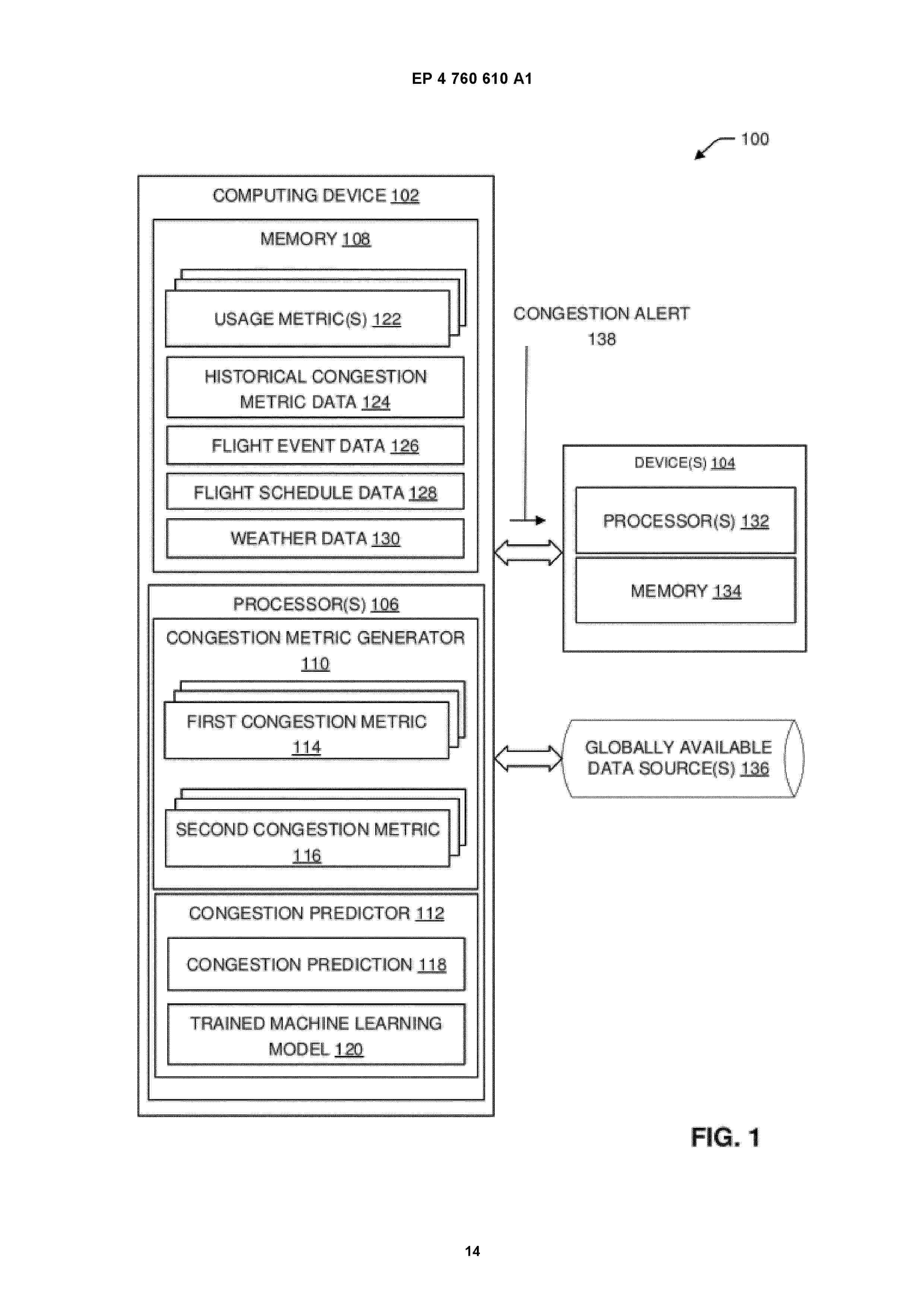
Resumen de: EP4760610A1
A device includes one or more processors configured to generate an operational congestion metric associated with a particular airport, wherein the operational congestion metric is based at least on one or more usage metrics for the particular airport. The one or more processors are configured to generate an impact congestion metric non-linearly based at least on the operational congestion metric. The one or more processors are configured to determine based on the impact congestion metric, a congestion prediction for the particular airport. The one or more processors are configured to communicate a congestion alert for the particular airport, wherein the congestion alert is based at least on the congestion prediction.
Resumen de: US2025050949A1
0000 An intermediate transition for connecting a crash cushion to a rigid structure includes a housing and an energy absorbing module. The housing defines an inner space and includes a top wall, a front wall, a rear wall, and a side wall. The front wall is operatively associated with the top wall and is operable to connect to the crash cushion. The rear wall is operatively associated with the top wall and is operable to connect to the rigid structure. The side wall is operatively associated with the top wall and includes a weakened portion. The energy absorbing module is located in the inner space of the housing.
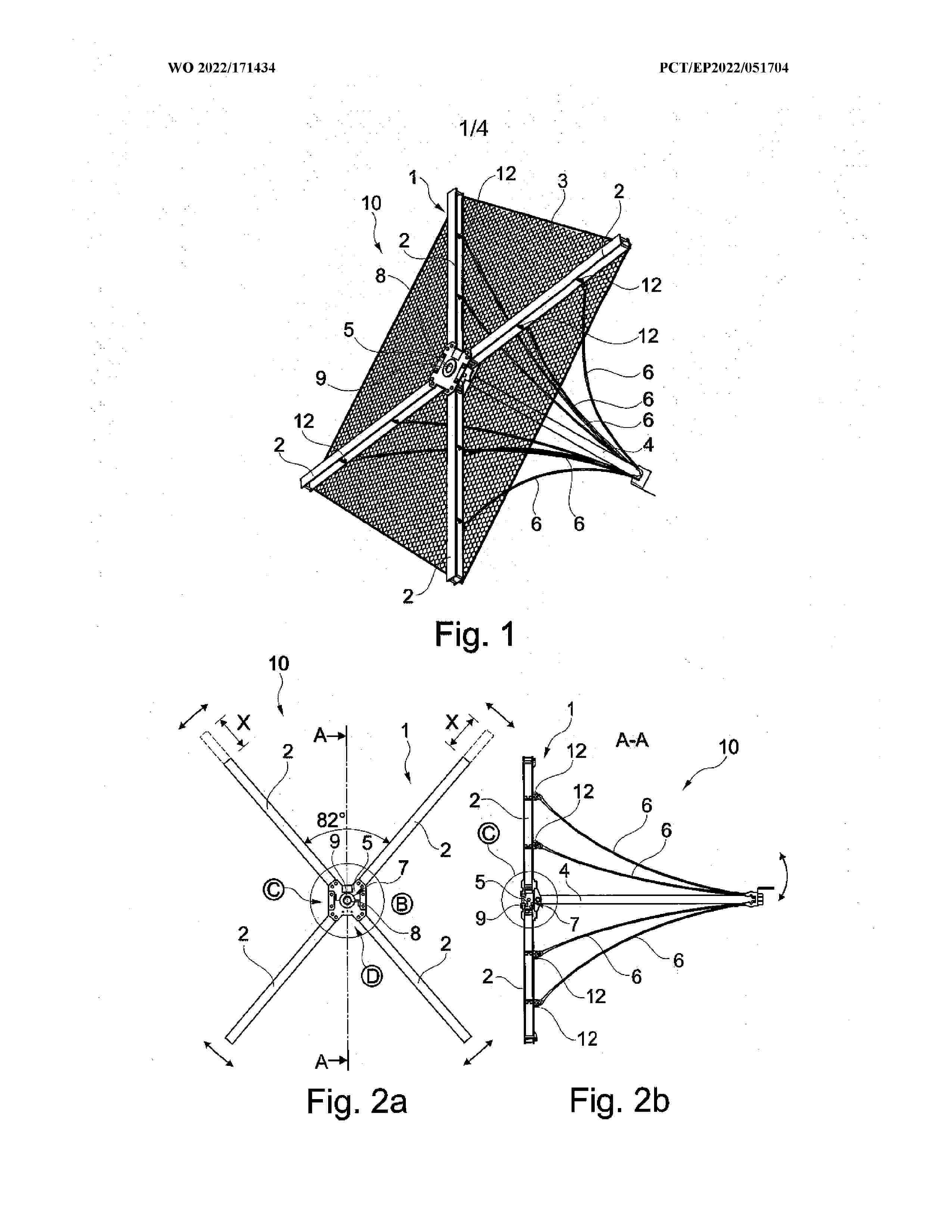
Resumen de: WO2022171434A1
An element (10) for slope securement particularly in the field of avalanche protection, ground, scree and rock retention or stream bed stabilization, having a substantially cross-shaped strut part (1) in the form of a framework which defines a plane and is composed of a plurality of coupled-together struts (2), having a planar holder (3) fastened to the strut part (1), and having an anchor rod (4) or anchor element which projects rearwardly substantially perpendicular to the holder (3) and to the strut part (1) and which is fastened to the strut part (1), wherein between a free end of the anchor rod (4) and the struts (2) are provided holding cables (6) for bracing the anchor rod (4) at a preset specific angle to the plane of the holder (3), wherein on the strut part (1) is provided a central coupling element (5) to which the struts (2) are each fastened releasably and/or adjustably with respect to one another by one of their ends, and wherein the anchor rod (4) is mounted on the coupling element (5) in particular such that it can move in all directions to adjust a mounting angle in relation to the plane of the holder (3).
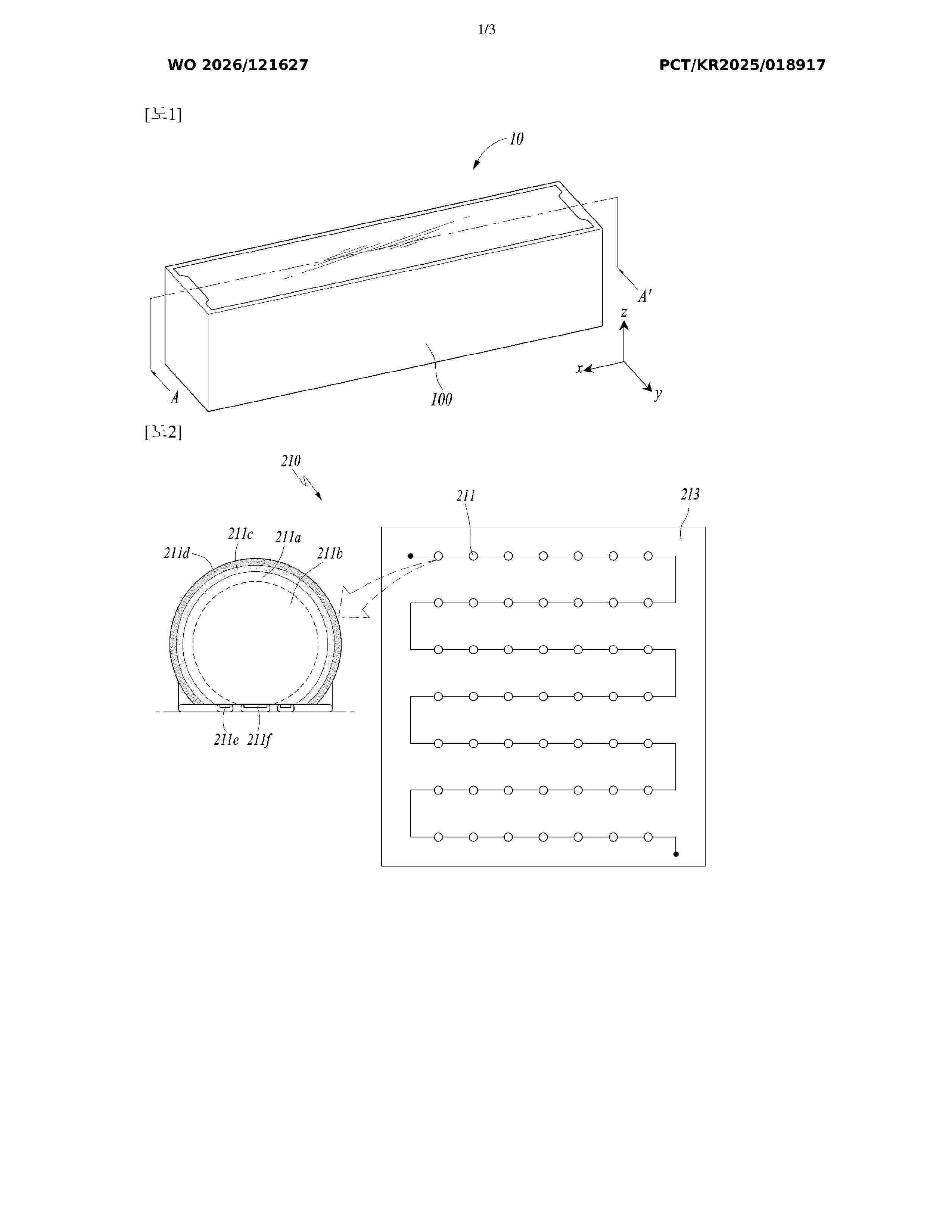
Resumen de: WO2026121627A1
The present invention relates to a smart lane, and the purpose of the present invention is to provide a smart lane that is operable without an external power supply by being equipped with a solar module and is capable of actively responding to traffic and environmental conditions in real time by including a light-emitting module and a communication module.
Resumen de: WO2026121302A1
Problem To provide an information processing system, a server, an information processing method, and a program with which it is possible to safely and efficiently operate a plurality of mobile bodies. Solution One embodiment of the present invention relates to an information processing system that manages the navigation of a plurality of mobile bodies, the information processing system being characterized by comprising: a time frame setting unit that sets a plurality of time frames along a time axis; a state management storage unit that stores identification information and work states of one or more mobile bodies; a slot management storage unit that stores the time frames and the identification information of the mobile bodies in association with each other; a work management unit that monitors the work states of the mobile bodies; and a navigation instruction unit that instructs the navigation of a mobile body that has entered a state enabling transfer, among the plurality of mobile bodies allocated to the same time frame.
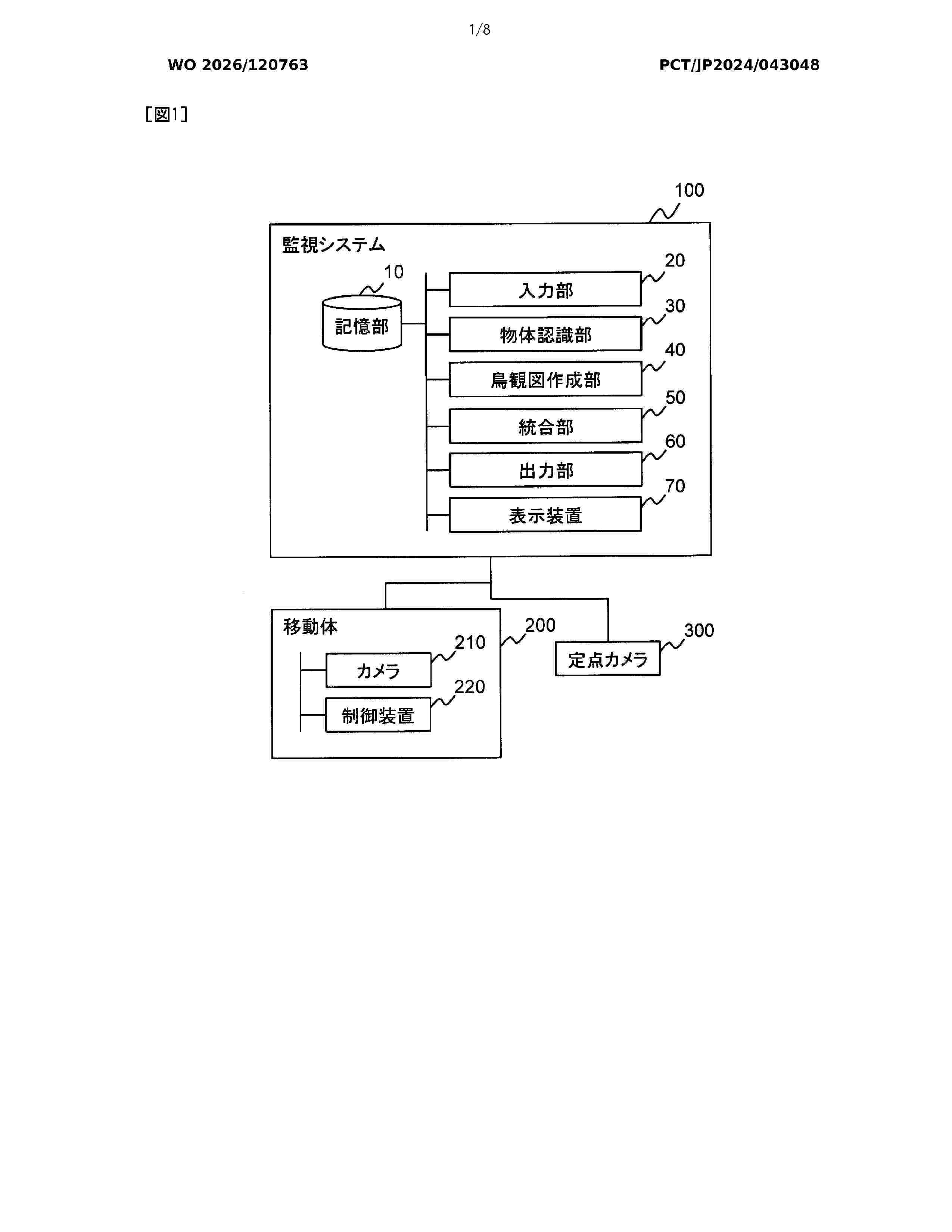
Resumen de: WO2026120763A1
In the present invention, an object position calculation unit calculates the position of an object detected by a fixed-point sensor which is installed at a fixed position. A bird's-eye view creation unit creates, from an image captured with a moving camera mounted on a moving object, a bird's-eye view in which the capturing direction of the moving camera is viewed from above. An integration unit generates an integrated image which is an image obtained by integrating the detected object in a corresponding position on the bird's eye view. An output unit outputs the integrated image.
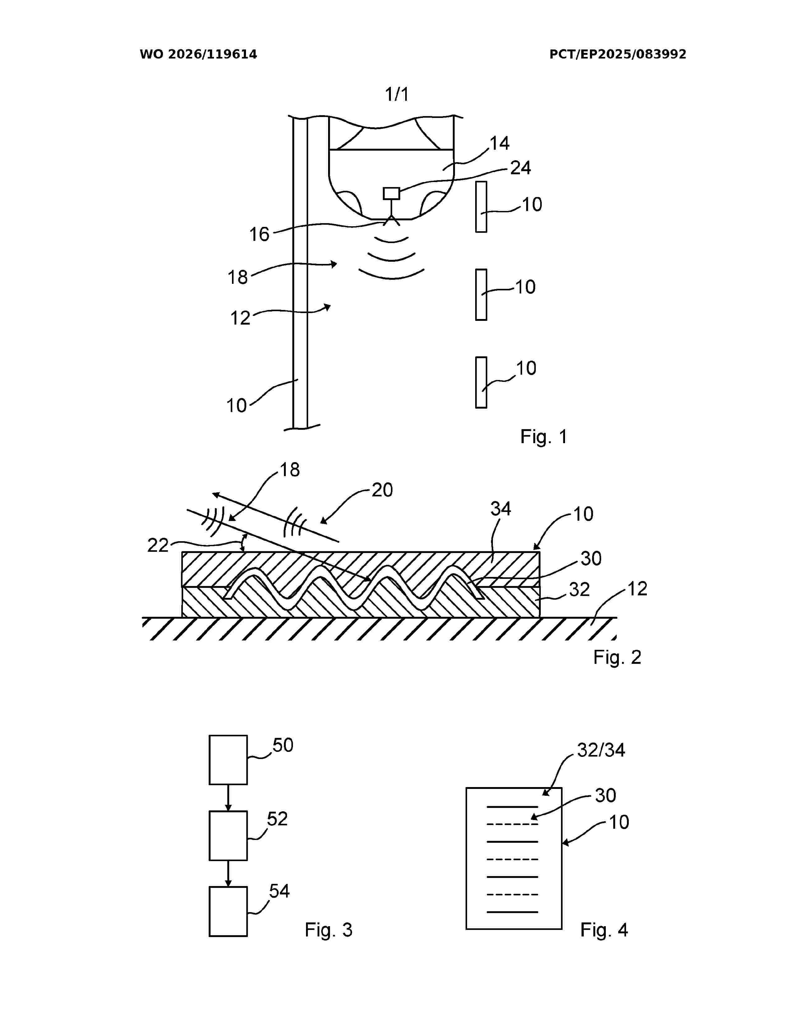
Resumen de: WO2026119614A1
The present invention relates to a road marking (10) for a road (12), wherein the road marking (10) comprises at least one radar reflection layer (30) provided on the road (12). Furthermore, the present invention relates to a road marking system and to a method for producing a road marking (10).
Resumen de: WO2026120686A1
In the present invention, an acquisition unit acquires first position information indicating the position of a first user at a first time and third position information indicating the position of the first user at a third time later than the first time. A determination unit determines second position information indicating the position of the first user at a second time between the first time and the third time, by processing the first position information and the third position information while using an estimation model which has learned, on the basis of movement history information of a group of first users, a staying location at which each user in the group of first users stayed between two discretionary locations. A presentation unit presents information based on the second position information.
Resumen de: WO2026118684A1
A data processing method and apparatus, a computer device, a storage medium and a program product. The data processing method comprises: acquiring first detection data of a first entry road segment of an intersection, wherein the first detection data comprises vehicle data of a plurality of first vehicles, and, within a detection period, the first vehicles pass through the first entry road segment and have not yet reached any exit road segment of the intersection (S501); on the basis of the first detection data, performing layered traffic condition detection on the first entry road segment, so as to obtain L types of traffic condition information of the first entry road segment within the detection period (S502); selecting from the intersection a first exit road segment where a flow direction has not been formed within the detection period, and acquiring traffic condition information of the first exit road segment (S503); and, if the traffic condition information of the first exit road segment successfully matches the L types of traffic condition information, configuring the traffic condition information of the first exit road segment to be traffic condition information of a first flow direction formed by the first entry road segment and the first exit road segment (S504). The data processing method can be used for determining flow-direction-level traffic condition information at intersections.
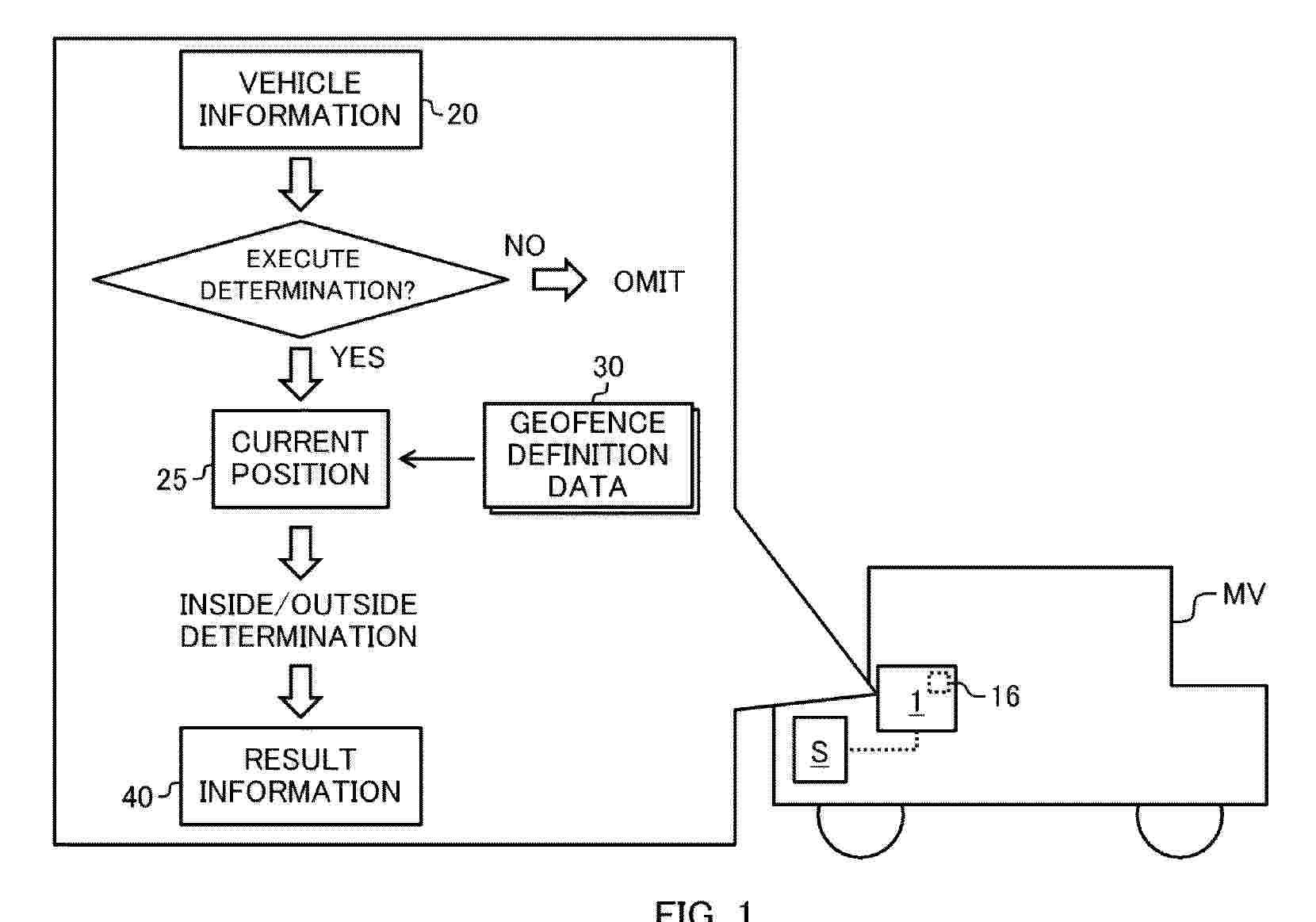
Resumen de: EP4756777A1
A program according to an aspect of the present disclosure is a program for causing an in-vehicle apparatus to execute an information processing method. The information processing method includes: acquiring vehicle information indicating a current state of a vehicle; selecting whether or not to execute a determination of a geofence according to the acquired vehicle information; when selecting to execute the determination of a geofence, acquiring a current position as measured by a positioning module, executing the determination of a geofence according to the acquired current position, and outputting information related to a result of the determination; and when selecting not to execute the determination of a geofence, omitting the execution of the determination of a geofence.
Nº publicación: EP4756778A1 10/06/2026
Solicitante:
INTERLIGHT SP S L [ES]
Interlight Sp, S. L.
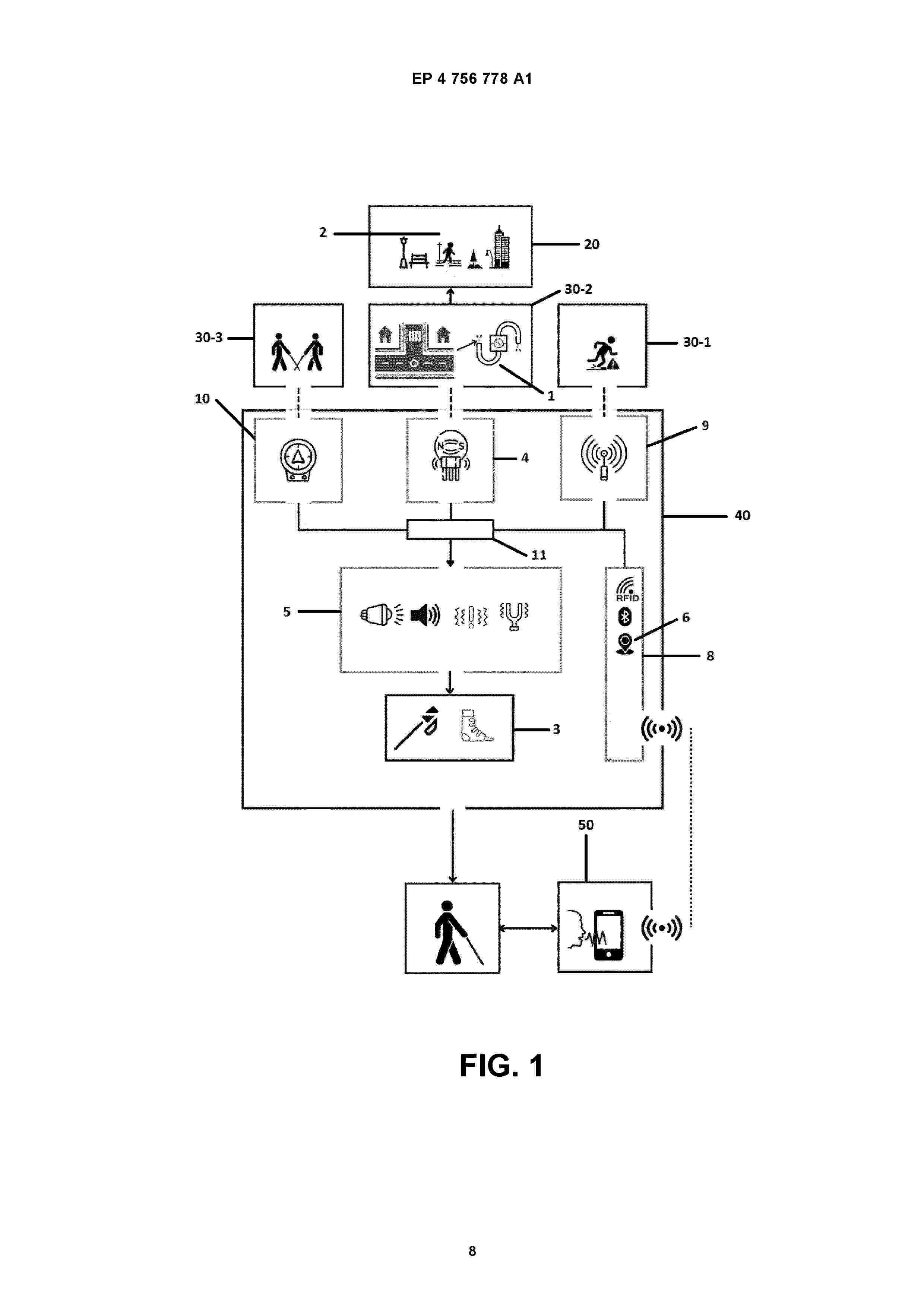
Resumen de: EP4756778A1
0001 The invention discloses an urban mobility assistance system and method that is intended to be integrated into an urban environment. The system notifies or alerts users about possible obstacles along the way and serves as a guide to direct users to a destination of interest. The assistance is produced by detecting, through a support element (3) carried by the user, an electromagnetic field generated by a conductor wire (1) that is installed below ground level when receiving alternating current. The invention provides an efficient solution to the lack of adaptability and customization in current assistance solutions for blind people, since it provides continuous and specific guidance based on information from the environment and the user's needs.
 BOPI
BOPI
 Sede Electrónica